About Mount Damavand Iran
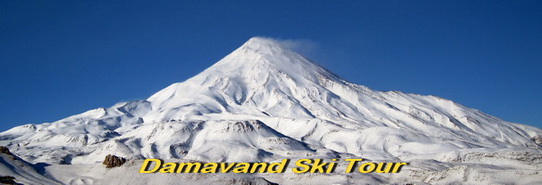
Mount Damavand (5,671 Meters, 18,606 Feet) is the Highest Volcano in Asia. This giant mountain is located in the Alborz Mountains near the south seashore of the Caspian Sea, 80 km North East of Tehran, Iran in Mazandaran province.
Damavand is a tipical cone-shape volcano with a narrow summit coverd with permanent snowcap, it is surrounded by many beautiful mountains in Alborz Chain, its snowy white summit and its regular clouds is the most attractive scene of Persia. Despite the fact that there is no historic eruptions recorded and it is believed to be a silent stratovolcano, but Damavand Volcano has fumaroles and sulfur gas coming out near the top and it is considered to be a potentially active dormant volcano. Visit also Damavand Ski.
Damavand South Route Difficulty
Damawand Physical Difficulty
Main Damavand Difficulty factors are Timing, the amount of snowfall, weather condition, your phisical fitness and Acclimatization. The south face is not technical and it has a mild slop for ski mountaineering. Damavand winter climb is very tough and you should be very fit enough and in good shape.
Camp 2 to Camp 3
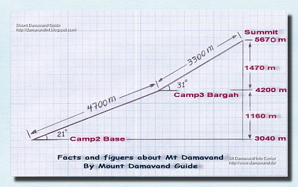
Ascend from Damavand Base Camp (or camp 2 Goosfand Sara) to Camp 3 Bargah Sevom takes about 4 to 5 hours on ski, 1250 meters vertical climb above 3000 meters.
Camp 3 to Summit
Ascend from Camp3 to Damavand Summit takes 5 to 8 hours ascend on ski, 1400 m vertical climb in a single day. Climb involves 1400 m+ of vertical climb above 4000 meters.
Carrying your baggage is naturally an additional difficulty. No rock/ice climbing experience is needed.
Damavand Weather Difficulty
Damavand Weather Condition plays an important role in winter.
In summer Damavand difficulty is compared to Mt Kilimanjaro in Tanzania and Mt Everest Base Camp in the Himalayan, but Damavand Winter Climb it is quite different and it should be compared to a 7000 meters peak.
Note
Off-season trekking, winter climbs and ski mountaineering specially in bad weather is very hard and dangerous.
Damawand Quick Facts
Alt: 18,606 Feet, 5,671 Meters,
Lat: 35, 57, 19 North
Lon: 52, 06, 36 East
Distance from Tehran: 80km
Best Starting point: Camp1 Polour.
Best Climb/Ski Side: South Route.
Best Trekking Time: mid June To mid August.
Best Ski/Snowboard Time: December to mid May.
Most Updated Weblog: Damavand Guide.
Most Informative Website: Damavand Info.
Volcanic Status: Potentially active (Dormant with fumaroles at the summit).
Rank: Highest peak in Iran, Highest volcano in Asia. Second highest volcano in the norther hemisphere.

Damavand Mountain Iran
Damavand Base Camp
Known as Goosfand Sara Campsite, Damavand Base Camp is the prime and most accessible base for trekking Mount Damavand in Iran. Situated at 3,040 meters above sea level, it features a small refuge, the Saheb al Zaman mosque, and a sheepfold. This base camp is the primary point for summer treks on the south route, with coordinates 35.9020° N latitude and 52.1094° E longitude.
Mount Damavand: Comprehensive Guide to Iran’s Iconic Peak – Facts, Figures, and More
Mount Damavand, a majestic volcanic peak located in northern Iran, stands as the highest mountain in the Middle East and the tallest volcano in Asia. Rising to an impressive 5,671 meters (18,606 feet) above sea level, this iconic summit attracts climbers, adventurers, and nature enthusiasts from around the globe. Located in the Alborz mountain range, it offers breathtaking views, unique geothermal features, and diverse flora and fauna. This guide covers everything you need to know about Mount Damavand, including its geographical location, climbing routes, weather conditions, and cultural significance. Discover essential tips for trekking, camping, and planning your journey to this extraordinary peak. Whether you’re an experienced climber or a curious traveler, Mount Damavand promises an unforgettable experience amidst nature’s wonders.
All Rights Reserved. © Damavand Ski Tour
All the material on this website is protected by copyright.